Here are profiles of the Mayor and each Councillor-by-Ward. We’ll also be adding an i>elect Quarterly Report for each Councillor and the Mayor during this term so you can assess for yourself how each incumbent is performing against the i>elect 6 priorities, including their motions, their votes, and their comments. And, we’ll provide a summary i>elect Quarterly Report for Council.
Mayor
Mayor: Fred Eisenberger
Year First Elected: Councillor – 1991-2000, Mayor – 2006 – 2010, 2014 –
Years Served: 19
Hamilton Population: 536,920
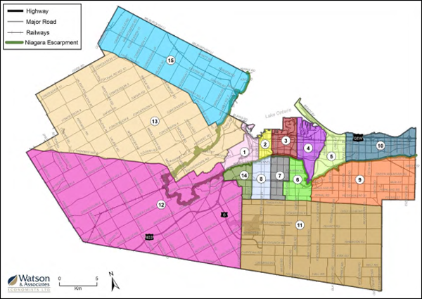
Ward 1
Councillor: Maureen Wilson
Year First Elected: 2018
Population: 29,850
Boundaries:
- Bordered by the Niagara Escarpment to the south
- Queen Street to the east
- Hamilton Harbour and Cootes Paradise to the north
- A green corridor running from Cootes Drive along the border of what was formerly the City of Hamilton and the Town of Dundas
- This ward is divided by the Highway 403 corridor running from the north-east to south-west
Also known as the Chedoke-Cootes area, Ward 1 is an urban ward, situated in the west end of Hamilton below the Niagara Escarpment (often referred to as the Mountain).
Ward 1 is home to Dundurn National Historic Site, McMaster University (part of Hamilton Health Sciences) and Chedoke Civic Golf Course.

Click on the Ward Map to view further detailed data and statistics
Ward 2
Councillor: Jason Farr
Year First Elected: 2010
Ward Population: 33,600
Boundaries:
- Escarpment to the south
- Hamilton Harbour to the north
- Queen Street to the west
- Wellington Street North to the east
Also known as the Downtown area, Ward 2 is an urban ward situated in the centre of the city below the Niagara Escarpment (often referred to as the Mountain). Ward 2 is considered the City’s downtown and is home to City Hall, Jackson Square, Gore Park, First Ontario Centre, the Hamilton Farmer’s Market, St. Joseph’s Hospital, the Art Gallery of Hamilton and Hamilton Place. It’s Hamilton’s smallest ward and the north section of Ward 2 includes the Harbourfront and Pier 4 Parks, as well as the Hamilton Waterfront Trail which links Wards 1 and 2.

Click on the Ward Map to view further detailed data and statistics
Ward 3
Councillor: Nrinder Nann
Year First Elected: 2018
Population: 41,205
Boundaries:
- Escarpment to the south
- Hamilton Harbour to the north
- Ottawa Street to the east
- Wellington Street North to the west
Also known as Hamilton Centre, Ward 3 is an urban ward situated in the lower city below the Niagara Escarpment (often referred to as the Mountain).
Approximately one third of this ward is comprised of industrial and commercial land including U.S. Steel Canada and ArcelorMittal Dofasco. It is also home to Hamilton General Hospital, St. Peter’s Hospital (both part of Hamilton Health Sciences), Tim Hortons Field and Gage Park.

Click on the Ward Map to view further detailed data and statistics
Ward 4
Councillor: Sam Merulla
Year First Elected: 2000
Population: 38,595
Boundaries:
- Escarpment and King’s Forest Golf Course to the south
- Hamilton Harbour to the north
- Ottawa Street to the west
- Red Hill Valley/Expressway to the east
Also known as the East Hamilton area, Ward 4 is an urban ward situated in the lower city below the Niagara Escarpment (often referred to as the Mountain). Approximately one-third of this ward is comprised of industrial and commercial land including ArcelorMittal Dofasco. Ward 4 is also home to the Centre on Barton, and the Pipeline Walkway.

Click on the Ward Map to view further detailed data and statistics
Ward 5
Councillor: Chad Collins
Year First Elected: 1995
Population: 41,855
Boundaries:
- Escarpment to the south
- Red Hill Valley/Expressway to the west
- Waters of Lake Ontario and Hamilton Harbour to the north.
- Gray Road to the east
Located just east of the Redhill area, Ward 5 is an urban ward situated in the lower city below the Niagara Escarpment (often referred to as the Mountain).
The eastern ward boundary follows along Gray Road from the escarpment to Lake Ontario. Ward 5 also includes the beach strip up to the Canal Bridge and the ship canal which separates the cities of Hamilton and Burlington. It is also home to St. Joseph’s Community Health Centre, Eastgate Square, Battlefield Park, Confederation Park and King’s Forest.

Click on the Ward Map to view further detailed data and statistics
Ward 6
Councillor: Tom Jackson
Year First Elected: 1983
Population: 38,650
Boundaries:
- Escarpment to th north
- Upper Red Hill Valley Expressway to the east
- Hydro corridor to the south
- Upper Gage Avenue to the west (between the LINC and the escarpment), but veers west to Upper Sherman Avenue from Rymal Rd. East to the LINC.
Also known as the East Mountain area, Ward 6 is primarily an urban ward situated in the east end of Hamilton on the Niagara Escarpment. Ward 6 runs along the north and east edge of the Escarpment.
It is divided by the Lincoln M. Alexander Parkway and includes the interchange with the Red Hill Valley Parkway. It has a pocket of light industrial and commercial land in the southeast corner and is home to the Mount Albion Conservation Area and Bernie Arbour Stadium.

Click on the Ward Map to view further detailed data and statistics
Ward 7
Councillor: Esther Pauls
Year First Elected: 2018
Population: 47,460
Boundaries:
- Escarpment to the north
- Upper Wellington Street to the west
- Hydro corridor to the south
- Edge of the Escarpment to the east along Upper Gage Road to the LINC, then west along the LINC to Upper Sherman, and down to Rymal Rd. East, ending at the hydro corridor
Also known as the Central Mountain area, Ward 7 is an urban ward, situated in the centre of Hamilton on the Niagara Escarpment.
The ward is divided by the Lincoln M. Alexander Parkway and is home to Limeridge Mall, the Sackville Hill Senior’s Centre, Sam Lawrence Park, Henderson General Hospital, and the Juravinski Cancer Centre (both part of Hamilton Health Sciences).

Click on the Ward Map to view further detailed data and statistics
Ward 8
Councillor: John-Paul Danko
Year First Elected: 2018
Population: 34,485
Boundaries:
- Escarpment to the north
- Hydro corridor to the south
- Upper Wellington Street to the east
- Garth Street to the west
Located within the West/Central Mountain area, Ward 8 is an urban ward, situated in the west end of Hamilton on the Niagara Escarpment.
Ward 8 is divided by the Lincoln M. Alexander Parkway. Home to Mohawk College of Applied Arts and Technology, Chedoke Hospital, St. Joseph’s Mental Health and Wellness Resource Centre and the Chedoke Rail Trail which connects Wards 1 and 8.

Click on the Ward Map to view further detailed data and statistics
Ward 9
Councillor: Brad Clark
Year First Elected: 2006
Population: 28,760
Boundaries:
- Niagara Escarpment to the north
- Hydro corridor and South Townline Rd to the south
- Municipal city limits to the east just past 11th Rd
- Upper Red Hill Parkway to the west
Known as Upper Stoney Creek, Ward 9 sits above the escarpment.
Home to Heritage Green Sports Park, the Eramosa Karst region and Felker’s Falls Conservation area among other locations of interest. Upper Centennial Parkway divides Ward 9 from its urban and rural portions, which are approximately 19% and 81% in land area respectively.

Click on the Ward Map to view further detailed data and statistics
Ward 10
Councillor: Maria Pearson
Year First Elected: 2003
Population: 37,215
Boundaries:
- Lake Ontario to the north
- Lower edge of the Escarpment to the south
- City municipal boundary to the east just past Fifty Rd.
- Grays Road to the west
Also known as the Lower Stoney Creek area, Ward 10 is primarily an urban ward situated below the Niagara Escarpment with an industrial and commercial corridor south of the Queen Elizabeth Way.
Home to Mohawk College STARRT Institute and a section of the Hamilton Waterfront Trail.

Click on the Ward Map to view further detailed data and statistics
Ward 11
Councillor: Brenda Johnson
Year First Elected: 2010
Population: 25,415
Boundaries:
- Hydro corridor to the north
- Municipal boundary to the south along Haldibrook Rd.
- Glancaster Rd. to the west
- City of Hamilton/Region of Niagara boundary to the east running along Westbrook Rd,
Ward 11 is generally comprised of the municipality of Glanbrook.
Home to Lake Niapenco, the Binbrook Conservation Area, and the John C. Munro Hamilton International Airport. It is also home to two major residential settlement areas, including Mount Hope and Binbrook, and is approximately 90% rural in area.

Click on the Ward Map to view further detailed data and statistics
Ward 12
Councillor: Lloyd Ferguson
Year First Elected: 2006
Population: 42,560
Boundaries:
- Former Town of Dundas and Highway 8 to the north
- Municipal boundary to the west
- Sawmill Road (the city limits) to the south
- Glanbrook Road to the east
Also known as the Ancaster area, Ward 12 also extends into the west Flamborough rural area.
Home to Redeemer University College, as well as part of the Dundas Valley Conservation Area.
There are several small to medium commercial and light industrial sections, including the Meadowlands Power Centre and the Ancaster Business Park. It is also home to several rural settlements including Copetown, Sheffield, Lynden and Jerseyville.

Click on the Ward Map to view further detailed data and statistics
Ward 13
Councillor: Arlene VanderBeek
Year First Elected: 2014
Population: 35,365
Boundaries:
- Milgrove Sideroad to the north
- Dundas municipal boundary to the east
- Hwy. 8 to the south
- Hamilton city limits along Gore Rd to the west
Ward 13 includes primarily the Community of Dundas is an urban and rural ward comprised of the former Town of Dundas. There was a substantial expansion for Ward 13 which extended into a large rural portion of Flamborough, extending from Greensville to the city limits. It is situated in the Dundas Valley.
Home to the African Lion Safari, Westfield Heritage Village, Dundas Valley School of Art, the Dundas Valley Conservation Area, a large section of the Royal Botanical Gardens, and Cootes Paradise. It is also home to several rural settlement areas such as Freelton, Kirkwall, Rockton and Greensville.

Click on the Ward Map to view further detailed data and statistics
Ward 14
Councillor: Terry Whitehead
Year First Elected: 2003
Population: 34,230
Boundaries:
- Escarpment to the north
- Hydro corridor to the south
- Garth Street to the east
- Municipal border to the west, extending beyond Scenic Drive into Ancaster to the 403 and the LINC.
Ward 14 is located in the western portion of the Hamilton Mountain.
Almost 1/2 of Ward 14 is comprised of residential lands, while another substantial percentage is made up of parks and open spaces.

Click on the Ward Map to view further detailed data and statistics
Ward 15
Councillor: Judi Partridge
Year First Elected: 2010
Population: 27,675
Boundaries:
- Puslinch Townline Road to the north
- Escarpment to the south
- Millburough Line to the east
- Highway 6 to the west
Ward 15, also known as the Flamborough East area is primarily a rural ward but includes some light industrial and commercial land as well as the urban area of Waterdown.
Home to Carlisle rural settlement area. Waterdown is considered one of the fastest growing residential areas in Hamilton.
